INTRODUCTION
"Kotahi te kohao te ngira e kuhuna ai te miro ma, te miro pango, te miro whero. I muri, kia mau ki te aroha, ki te ture, me te whakapono."
There is but one eye of the needle through which the white, black and red threads must pass. After I am gone, hold fast to love, to the law, and to the religion of Christ.
(Reed's Maori Proverbs)
These famous words were spoken by Potatau Te Wherowhero, the first Maori king, at his Coronation in
1858, in response to the charge given byTe Heuheu.
The district of Tauwhare used to begin about 10 kilometres east of the present day Hamilton City boundary. T. E. Dodd's 720 acre farm, bounded by the Tauwhare Road and Eureka Avenue, would probably be included in present day Newstead, yet in 1883 it was part of the Tauwhare sub-division of the Eureka Estate. Similarly, the northern part of the district between the confiscation line and the Tauwhare-Morrinsville Road, would today be considered part of Eureka, although a century ago it was known as the Tauwhare flats.
The total area of the district is approximately 15,650 acres, of which about 6,800 acres lie west of the confiscation line, and were thus confiscated by the Crown. The rest lies east of the confiscation line and was bought from Maori owners.
Tauwhare, a house of rest, is an apt name for the district, from both Maori and European viewpoints.
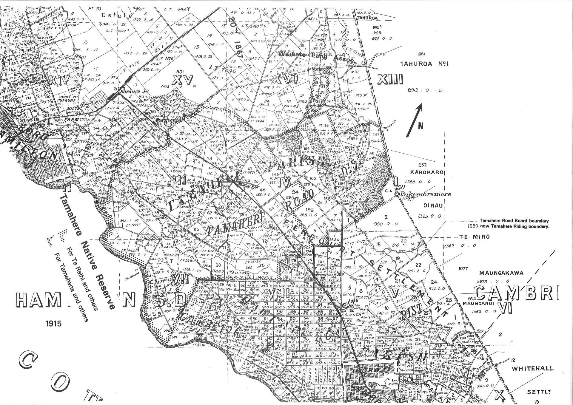
Maori travellers from Waahi, the principal Waikato Pa at Huntly, would rest here awhile on their way to Waharoa or Peria near Matamata. The tracks from Tauwhare Pa to these places followed the high ground just north of Mrs M. Hapi's house, crossed the lands bought by the three Shaw brothers in 1880, then went south-east up two parallel ridges on the Karokaro Block to join another well defined track running east from Pukemoremore. An old map dated 1915 shows these tracks, and the writer came across them when breaking in his farm in the 1950's. One is shown following a ridge above the farm road he had bulldozed in 1951. It went up the airstrip to join the other which followed the next ridge to the east. The hollowed-out path of the second is still visible in parts.
In May 1891, Tawhiao, the second Maori king, opened the Maori Parliament House at Te Miro in the Maungakawa Range. There was a village there and wheat was grown on land now farmed by Mr R. Muirhead. These tracks may still have been in use then, although most travelled to the annual sessions of Parliament by way of Cambridge.
Tauwhare was also on the crossroads to Tainui Pa at Matangi, Maniapoto at Tamahere, and various places on the banks of the Waikato River. A track to Rukumoana Pa, near Morrinsville, also led from Tauwhare, so the pa at Tauwhare would have seen many travellers going and coming.
The spelling Tawhare also appears on several old documents, notably the subdivision plans for the township auction in 1882, and the tender specifications for the first school built in 1884. Mrs M. Hapi has long believed the name meant "thy house", ta being the possessive pronoun singular and whare of course a house.
Perhaps the district was known by different but similar names at different times. Other spellings the writer has seen, have been Taweri and Tauwhere but these may merely reflect pakeha confusion.
Europeans passing through from Hamilton, Cambridge or Morrinsville would have found a meal and lodging at the Tauwhare Hotel, built by the Waikato Land Association in 1883. This place of rest for man and beast would have been most welcome. Perhaps they rode a hack or "enjoyed the luxury" of travelling in one of "King" Carter's coaches which ran from Cambridge to Rotorua as well as via Tauwhare to "the Piako", that is Morrinsville and beyond.
Drovers moving stock along the same route would often use the Accommodation House for an overnight stay, putting their charges in the paddocks at the rear. Behind the house were four loose boxes for the horses. J. McDonald and his sons used to drive cattle to the Ohaupo stock sale which was for many years the largest sale in the Waikato. The McDonald farm was the Pakarau Block in Piako County and they would aim to reach Tauwhare by the first night and move on next day. They bought their farm in 1872 for two shillings and sixpence per acre.
Overlooking Tauwhare to the south-east is Pukemoremore, the probable meaning being bald or smooth hill. Until the recent invasion of pine trees it certainly lacked any conspicuous features. The writer, who spent his youth on his father's farm just south east of Pukemoremore, remembers the bare slopes of the mountain, exposed by fires which swept across quite frequently. Much surface stone lies under the scrub. A very popular ride or hike was the trip up "Puke" as it was generally called. There was a well-worn track which we followed along the top of the eastern ridge, through a gate in the fence on the Confiscation Line, and continued down to Mr Bruce Beer's present farm. Many school parties used the approach from the western end. The effort involved in climbing the 1119 foot high mountain was rewarded by the best view of the Waikato in the Waikato.
The view extended as far south as Ruapehu, west to Mt. Karioi at the south head of the Raglan Harbour, to Mt. Te Aroha and the Kaimai Range in the east, and well north to Taupiri. In 1935, to mark the 25th anniversary of the Coronation of King George V, the Boy Scouts lit a bonfire on the summit. This was also done at the same time on many other peaks around the Waikato. Unfortunately the growth of pine trees has limited the view in recent years.
So much for the distant horizons. In the immediate foreground, from Pukemoremore to Lang Road and eastward, lies the Karokaro block, originally of 1388 acres grantd to Hamiora Te Ahuroa and 7 others in 1868. Karokaro A is still in Maori ownership, while blocks B and C are farmed by B. Pollock and W. Harbutt.
In the middle distance to the north east lies the Tahuroa number one block. All of Scotsman's Valley north of the Karokaro block, and those properties at the southern end of the Pakaroa Range served by Tahuroa Road, lie within Tahuroa number one. Mt. Tahuroa, 675 feet high, stands on the boundary between the farms of L. Hoyle and R. Nicholls, and was much used by early surveyors.
Tahuroa number one covered 8,912 acres and was granted by the Crown on the 14th December 1869 to 10 Maori chiefs representing the Ngati Haua occupants. The 10 named were Penetito, Tuwhenua, Rapata Te Paoa, Eruera Te Ngahuru, Tene Ponui, Raiha Te Mango, Pipikura Te Toi, Pipi Te Toi, Mere Te Ngahuru and Te Ratapu. Governor Bowen and the Secretary for Crown Lands, A. Domett, both signed the document. Domett had been Premier in 1862 during the Waikato War. The boundaries of the block were the Karo Karo block on the south and a Waitakaruru Stream which flows alongside the Te Miro road, then on the east the Tahuroa number two block (now H. Stringfield's eastern boundary) to where it meets the Kuranui block, then westward to the Confiscation boundary which it follows south back to the junction of Pukemoremore and Lang roads.
Mrs Mary Hapi of Tauwhare says the name Tahuroa was originally Tahuhuroa meaning the long climb. In earlier times, Maoris travelling from Tauwhare to Rukumoana near Morrinsville, crossed the Pakaroa Range on a track approximating the present day Tahuroa Road - hence the long climb.
On the 27th April 1870, the grantees, Penetito and 9 others, sold 4,146 acres to the Crown for Seven hundred and twenty five pounds, fourteen shillings, being three shillings and six pence per acre. The Crown's agent was F. D. Fenton, Chief Judge of the Native Land Court. On the same day, the same vendors sold 2,000 acres to the Crown for Two hundred and fifty pounds or two shillings and sixpence per acre. George Drummond Hay bought this land for the Crown. The remaining 2,766 acres later became part of the Te Miro Settlement. Hay, of Scottish aristocratic descent, was a Land Purchase Commissioner for the government, and a surveyor. He was said to favour the kilt, and one suggested origin of the name Scotsman's Valley was his association with its purchase. This is doubtful as he did not own property there although he did own land further east in Piako County. J. B. Whyte, who bought the land from the Crown in 1876, was another Scot, who hailed from Glasgow. As well, the Shaw brothers, who came from Muirkirk, Scotland, and another early landowner Thomas Paton, who bought two blocks of land from Whyte in 1879, were also Scots. Paton kept up the Caledonian influence by selling to Eyre in 1895. Paton's original 506 acres is now owned by Silvester Bros.
If we look to the north west from our vantage point atop Pukemoremore, we see the vast area granted to the Loan and Mercantile Agency Company Limited in 1876. In area 86,502 acres, it extended from the Confiscation boundary (which passed over the summit of Pukemoremore) in the east, almost to Hamilton in the west, and from the Tauwhare-Newstead road in the south to Taupiri far to the north.
To the immediate west of Pukemoremore lie the lands included in the Tamahere Native Reserve of 26,790 acres in three sub-divisions. It extended from Pukemoremore westward to the Waikato River.
So much for the broad overview of the Tauwhare district from the mountain top. A more detailed history of its component parts appears in subsequent chapters.